
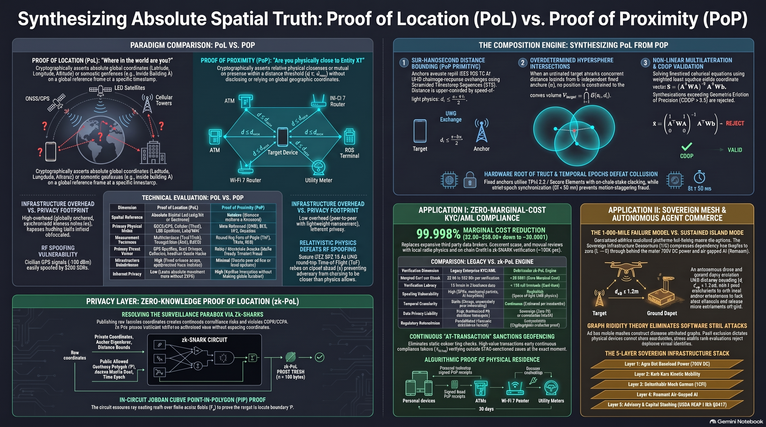
Comparative Summary: Legacy Client-Reported Location vs. Anchor-Verified Cryptographic Spatial Proofs
- The Crisis of Client-Reported Location Systems
1.1 The Fundamental Flaw: Target-Side Resolution
Traditional geolocation architectures depend on a foundational design assumption known as target-side coordinate resolution. Under this legacy model, the target device—whether a smartphone, IoT telemetry device, or autonomous vehicle—is entrusted to observe external signals, calculate its own geographic coordinates, and report those coordinates to a remote application server, enterprise API, or smart contract.
This model introduces a structural conflict of interest. In modern distributed systems, decentralized finance (DeFi), and decentralized physical infrastructure networks (DePIN), claiming a specific physical location often unlocks financial rights, jurisdictional access, or operational token rewards. When the entity that stands to benefit from asserting a specific coordinate is also the entity tasked with measuring and reporting it, the system creates an inherent incentive and opportunity for deception. Because consumer operating systems and lightweight edge client software run untrusted code on the user’s hardware, software-layer location reporting can be easily intercepted and altered before data ever reaches a verifier.
Key Concept Callout: Target-Side Resolution vs. Anchor-Side Attestation
- Target-Side Resolution (Legacy): The untrusted client device receives unauthenticated external signals, computes its own global coordinates, and self-reports its location to the network. Trust is mistakenly placed in the self-reporting client.
- Anchor-Side Attestation (Cryptographic): The untrusted client device remains agnostic of its position and merely completes physical challenge-response exchanges. Fixed, authenticated infrastructure nodes (anchors) measure physical signal propagation metrics and cryptographically sign distance attestations to bound the target’s position.
1.2 Anatomy of Legacy Geolocation Exploits
Legacy positioning relies primarily on three traditional mechanisms: Global Navigation Satellite Systems (GNSS/GPS), Terrestrial Cellular and Wi-Fi Triangulation, and IP Geolocation. Each mechanism suffers from severe physical or architectural vulnerabilities that can be exploited using inexpensive software and hardware tools.
Legacy Location Mechanism Primary Attack Vector Tools Required for Exploitation Impact on Trust
Global Navigation Satellite Systems (GNSS/GPS) Unencrypted, low-power civilian RF signal override (GPS Spoofing) Low-cost Software-Defined Radios (SDRs) (e.g., HackRF under $200) Zero physical trust. Adversaries generate fake satellite signals (-130 dBm override) to place devices at arbitrary coordinates and timestamps globally.
Terrestrial Wi-Fi & Cellular Triangulation Ingestion of fake beacon frames and manipulated signal lists (OS Mock Locations) Kernel jailbreaks, developer hooks, or OS-level location mockers Systemic software bypass. Malicious applications bypass sensor layers completely by injecting synthetic coordinates directly into kernel memory.
IP Geolocation Topological routing redirection and proxy tunneling (Network Proxy Evasion) VPNs, TOR exit nodes, and commercial residential proxy networks Complete jurisdictional failure. IP addresses represent routing paths rather than physical space, allowing users to mask their true regional origin for $0.05/GB.
For trust-critical applications—such as automated financial compliance, high-value physical access control, or autonomous edge settlement—these vulnerabilities render legacy client-reported location unusable. A system that can be deceived by a $200 radio transmitter or a software proxy cannot serve as a foundation for physical security, legal compliance, or machine-to-machine commerce.
1.3 Section Narrative Bridge
The systemic collapse of software-reported positioning demonstrates that digital assertions alone cannot establish spatial presence; authenticating location requires grounding spatial claims directly in non-deceivable physical laws.
- The Physical Primitive: Proof of Proximity (PoP) & Relativistic Physics
2.1 Inverting the Trust Architecture
To overcome the vulnerabilities of target-side resolution, cryptographic spatial networks execute a paradigm shift to Anchor-Verified Distance Bounding. Rather than trusting the client’s internal assertions, the system delegates coordinate awareness away from the lightweight, untrusted target device to a perimeter of fixed, authenticated hardware anchors.
These anchors operate as immutable trust foundations equipped with Hardware Roots of Trust, such as Common Criteria EAL6+ Secure Elements or Trusted Platform Modules (TPM 2.0). These enclaves enforce key non-exportability, generating private signing keys (sk_{A_i}) internally that can never be extracted via software interfaces. Furthermore, anchor hardware enclosures are wrapped in active physical tamper-detection loops; any mechanical breach, trace interruption, or enclosure penetration triggers silicon zeroization, destroying ephemeral state and master private keys in nanoseconds. Anchors operate within an on-chain registry secured by economic staking and automated slashing mechanisms, where submitting conflicting, geographically impossible, or forged attestations results in the immediate forfeiture of staked collateral.
- The Untrusted Target: Acts purely as a physical reflector. It possesses no global coordinate awareness, carries no heavy baseband satellite processing hardware or patch antenna arrays, and is only required to execute immediate, physical-layer bit reflections over short-range radio protocols.
- The Authenticated Anchor Perimeter: Consists of geographically fixed, tamper-resistant hardware units holding non-exportable cryptographic signing keys. Anchors perform spatial measurement, calculate physical distance bounds, and issue cryptographically signed receipts (Proofs of Proximity).
2.2 Speed-of-Light Limits & UWB Hardware Standardization
The fundamental atomic building block of physical spatial trust is the Proof of Proximity (PoP). PoP answers a strictly local question: “Is Target X within a maximum physical distance \hat{d}_i of Anchor Y?”
PoP grounds its security in relativistic physics: electromagnetic radiation propagates through free space at the speed of light (c \approx 299,792,458\text{ m/s}, or roughly 0.3\text{ meters per nanosecond}). By measuring the Round-Trip Time-of-Flight (\text{ToF}) of radio signals between a verifier anchor located at certified coordinates \mathbf{s}_i = [x_i, y_i, z_i]^T and a target at unknown coordinates \mathbf{x} = [x, y, z]^T, the system establishes an upper bound on physical distance using the propagation invariant:
\hat{d}_i \le \frac{c \cdot \Delta t_i}{2}
Because information cannot travel faster than the speed of light (c), an adversary cannot manipulate time to appear physically closer to an anchor than it actually is. An attacker can intentionally delay its response (making itself appear farther away), but it cannot advance its response in time without correctly predicting unpredictable cryptographic challenge bits before they physically arrive.
Legacy proximity systems relying on Received Signal Strength Indication (RSSI) over Bluetooth Low Energy (BLE) or Wi-Fi fail because signal power follows the log-distance path loss model and is easily manipulated using high-gain directional antennas or RF power amplifiers. Modern cryptographic PoP standardizes on IEEE 802.15.4z Ultra-Wideband (UWB). UWB utilizes wide frequency bandwidths (B \ge 499.2\text{ MHz}) to produce extremely short sub-nanosecond pulse widths (\approx 2\text{ ns}), allowing time-to-digital converters to log timestamps with picosecond resolution (\le 15.65\text{ ps}). Crucially, IEEE 802.15.4z embeds a cryptographically pseudo-random Scrambled Timestamp Sequence (STS) directly into the physical radio frame, modulated via binary phase-shift keying (BPSK) keyed by an ephemeral session key. This prevents preamble injection, cycle slips, and physical-layer signal relay manipulation.
The cryptographic distance-bounding protocol operates across four distinct phases:
- Commitment & Nonce Exchange: The verifier anchor generates a cryptographically random challenge nonce (N_v \in_R {0, 1}^{128}) and the target generates an ephemeral nonce (N_p \in_R {0, 1}^{128}). The target transmits a signed cryptographic commitment (\text{Com}T = \text{HMAC}{SHA256}(pk_T \parallel N_p, N_v)) back to the anchor.
- Rapid Pulse Exchange: The anchor and target derive a shared session key (K_{\text{session}} = \text{HKDF}(N_v \parallel N_p)) to key their UWB STS baseband hardware. Over m discrete physical pulses, the anchor transmits random challenge bits (C), and the target’s hardware immediately reflects response bits (R = C \oplus K).
- Time-of-Flight Measurement: High-precision time-to-digital converters in the anchor hardware log exact transmission timestamps (t_{0, j}) and reception timestamps (t_{1, j}), calculating elapsed propagation time \Delta t_i = \frac{1}{m} \sum_{j=1}^m (t_{1, j} – t_{0, j} – t_{\text{proc}}), where t_{\text{proc}} is the target’s calibrated hardware processing delay.
- Attestation Signing / Verification: The anchor computes the maximum physical distance \hat{d}_i \le \frac{c \cdot \Delta t_i}{2} and emits a signed Proof of Proximity Receipt (\text{PoP}i = (\text{ID}{A_i}, \text{ID}_T, \mathbf{s}i, \hat{d}i, E_n, \sigma{A_i})), signed via Ed25519 or ECDSA over its non-exportable hardware key sk{A_i}.
2.3 Section Narrative Bridge
While a single distance bound proves local physical closeness, multiple independent, relative distance bounds (PoPs) can be combined mathematically to pinpoint a target’s absolute global coordinates (PoL).
- Synthesizing Absolute Spatial Truth: From PoP to Proof of Location (PoL)
3.1 Geometric Multilateration & Overdetermined Spheres
When an untrusted target device executes concurrent distance-bounding exchanges with k independent, spatially distributed anchors, it collects a bundle of signed Proofs of Proximity. Each individual \text{PoP}_i defines a closed Euclidean ball \mathcal{B}(\mathbf{s}_i, \hat{d}_i) centered at anchor position \mathbf{s}_i = [x_i, y_i, z_i]^T with radius \hat{d}_i:
\mathcal{B}(\mathbf{s}_i, \hat{d}_i) = \left{ \mathbf{p} \in \mathbb{R}^3 ;\middle|; |\mathbf{p} – \mathbf{s}_i|_2 \le \hat{d}_i \right}
By composing these relative distance assertions together, the target’s absolute global position \mathbf{x} = [x, y, z]^T is mathematically constrained to the overdetermined spatial intersection volume \mathcal{V}_{\text{target}}:
\mathcal{V}{\text{target}} = \bigcap{i=1}^k \mathcal{B}(\mathbf{s}_i, \hat{d}_i)
To collapse this non-linear intersection volume into a definitive spatial coordinate vector \hat{\mathbf{x}}, the system linearizes the spherical system relative to a reference anchor (anchor 1, \mathbf{s}_1). Subtracting the distance equation of anchor 1 from the i-th anchor equation yields a system of linear equations:
2(x_i – x_1)x + 2(y_i – y_1)y + 2(z_i – z_1)z = (\hat{d}_1^2 – \hat{d}_i^2) + (r_i^2 – r_1^2)
where r_i^2 = x_i^2 + y_i^2 + z_i^2 represents the squared norm of anchor i’s coordinates. Expressed in matrix notation as \mathbf{A}\mathbf{x} = \mathbf{b}:
\mathbf{A} = 2 \begin{bmatrix} x_2 – x_1 & y_2 – y_1 & z_2 – z_1 \ x_3 – x_1 & y_3 – y_1 & z_3 – z_1 \ \vdots & \vdots & \vdots \ x_k – x_1 & y_k – y_1 & z_k – z_1 \end{bmatrix}, \quad \mathbf{b} = \begin{bmatrix} (\hat{d}_1^2 – \hat{d}_2^2) + (r_2^2 – r_1^2) \ (\hat{d}_1^2 – \hat{d}_3^2) + (r_3^2 – r_1^2) \ \vdots \ (\hat{d}_1^2 – \hat{d}_k^2) + (r_k^2 – r_1^2) \end{bmatrix}
Using the Moore-Penrose pseudoinverse, the weighted least-squares solution for the estimated coordinate vector \hat{\mathbf{x}} is:
\hat{\mathbf{x}} = (\mathbf{A}^T \mathbf{W} \mathbf{A})^{-1} \mathbf{A}^T \mathbf{W} \mathbf{b}
where \mathbf{W} = \text{diag}(\sigma_1^{-2}, \sigma_2^{-2}, \dots, \sigma_k^{-2}) represents the inverse variance covariance matrix of anchor ranging errors.
- Solvability Criteria (Minimum Anchor Bounds):
- 2D Planar Resolution (Surface / Floor Level): Requires a minimum of k \ge 3 non-collinear anchor proofs, ensuring \text{rank}(\mathbf{A}) = 2.
- 3D Volumetric Resolution (Latitude, Longitude, Altitude): Requires a minimum of k \ge 4 non-coplanar anchor proofs, ensuring \text{rank}(\mathbf{A}) = 3.
3.2 Geometric Quality (GDOP) and Temporal Synchronization
Generating a valid Proof of Location requires enforcing strict operational constraints: Geometric Dilution of Precision (GDOP), Temporal Epoch Synchronization, and Geodetic Integrity.
GDOP quantifies how anchor geometry magnifies ranging errors into spatial positioning uncertainty. Defining unit line-of-sight direction vectors from estimated position \hat{\mathbf{x}} to anchor \mathbf{s}_i as \mathbf{u}_i = \frac{\hat{\mathbf{x}} – \mathbf{s}_i}{|\hat{\mathbf{x}} – \mathbf{s}_i|_2}, we construct the design matrix \mathbf{H} and error covariance tensor \mathbf{Q}:
\mathbf{H} = \begin{bmatrix} \mathbf{u}_1^T & 1 \ \mathbf{u}_2^T & 1 \ \vdots & \vdots \ \mathbf{u}_k^T & 1 \end{bmatrix}, \quad \mathbf{Q} = (\mathbf{H}^T \mathbf{H})^{-1} = \begin{bmatrix} \sigma_x^2 & \cdot & \cdot & \cdot \ \cdot & \sigma_y^2 & \cdot & \cdot \ \cdot & \cdot & \sigma_z^2 & \cdot \ \cdot & \cdot & \cdot & \sigma_t^2 \end{bmatrix}
\text{GDOP} = \sqrt{\text{Tr}(\mathbf{Q})} = \sqrt{\sigma_x^2 + \sigma_y^2 + \sigma_z^2 + \sigma_t^2}
If verifying anchors are collinear or coplanar, \mathbf{H}^T \mathbf{H} approaches singularity, causing \text{GDOP} \to \infty and stretching the intersection volume into an unconstrained ellipse. Verifiers automatically reject proofs where \text{GDOP} > 3.5.
To prevent motion-staggering fraud—where a malicious target pings Anchor 1 at time t_0, drives ten miles, and pings Anchor 2 at time t_1 to synthesize a false intersection point—anchors synchronize clocks via PTP (IEEE 1588v2) to enforce strict Epoch-Bounded Validity Windows (\delta t < 50\text{ ms}). All constituent PoP receipts must share an identical epoch identifier (E_n). Furthermore, anchors run continuous geodetic self-audits using carrier-phase differential GNSS (RTK); any physical displacement exceeding 5\text{ cm} revokes the anchor’s active signing key and triggers on-chain stake slashing.
Warning: Spatial Ambiguity & Spoofing Risks
- High GDOP Vulnerability: Anchor placements producing \text{GDOP} > 3.5 degrade spatial resolution severely. Verifier contracts reject synthetic location claims generated from degenerative, coplanar, or collinear anchor arrangements.
- Temporal Window Exploits: Allowing loose attestation time windows enables adversaries to collect distance receipts sequentially across miles, synthesizing false geometric intersections. All constituent PoP receipts must share an identical epoch identifier (E_n).
3.3 Section Narrative Bridge
Constructing an absolute Proof of Location solves physical spoofing, but broadcasting raw global coordinates across public ledgers creates a severe surveillance risk.
- Resolving the Surveillance Paradox: Zero-Knowledge Spatial Proofs (zk-PoL)
4.1 The Privacy Dilemma of Absolute Positioning
While proving absolute geographic coordinates solves physical security risks, broadcasting raw location data (x, y, z, E_n) introduces a severe surveillance paradox. Continuously publishing coordinate receipts to public ledgers or enterprise databases enables granular tracking of individuals, reveals sensitive commercial trade routes, and directly violates data protection mandates like GDPR Article 4(1), which classifies raw location coordinates as protected Personal Data.
This creates a fundamental conflict: verifiable physical presence vs. surveillance-grade tracking.
4.2 Circuit Architecture: Proving Geofence Compliance in Zero-Knowledge
To resolve this dilemma, spatial networks combine physical multilateration with zero-knowledge cryptography—specifically Zero-Knowledge Succinct Non-Interactive Arguments of Knowledge (zk-SNARKs like Groth16 or Nova folding schemes over cycle curves).
In a Zero-Knowledge Proof of Location (zk-PoL) pipeline, the target device ingests its raw coordinates, anchor signatures, and distance measurements as private witness variables inside an arithmetic proving circuit. The circuit evaluates these hidden variables against public constraints, generating a succinct cryptographic proof (\pi).
Private Inputs (Hidden Witness \mathbf{w}) Public Verification Inputs (\mathbf{x}_{\text{pub}})
Target True Absolute Coordinates \mathbf{x} = [x, y, z]^T \in \mathbb{F}_p^3 Authorized Boundary Polygon \mathcal{P} = {\mathbf{v}_1, \mathbf{v}_2, \dots, \mathbf{v}_m} \subset \mathbb{F}_p^2
Anchor Certified Coordinates {\mathbf{s}_1, \dots, \mathbf{s}_k} \subset \mathbb{F}_p^3 Active Temporal Epoch Identifier E_n \in \mathbb{F}_p
Measured Proximity Distance Bounds {\hat{d}_1, \dots, \hat{d}_k} \subset \mathbb{F}p On-Chain Anchor Registry Merkle Root \mathcal{R}{\text{anchors}} \in \mathbb{F}_p
Cryptographic Anchor Signatures {\sigma_1, \dots, \sigma_k} & Merkle Paths Verification Output: Succinct Proof \pi (130–384 bytes, O(1) complexity)
The internal Rank-1 Constraint System (R1CS) arithmetic circuit enforces four key mathematical constraints:
- Anchor Membership: Verifies via Merkle inclusion proofs (\text{MerkleVerify}(\mathcal{R}{\text{anchors}}, \mathcal{H}(pk{A_i}), \text{Path}_i) == 1) that each participating anchor is registered in the public anchor root.
- Signature Verification: Validates via EdDSA/Poseidon constraints (\text{VerifyEdDSA}(pk_{A_i}, \sigma_i, \mathcal{H}(\mathbf{s}_i \parallel \hat{d}_i \parallel E_n)) == 1) that each attestation was signed by an active anchor key.
- Distance Invariants: Asserts that (x – x_i)^2 + (y – y_i)^2 + (z – z_i)^2 + \text{Slack}_i = \hat{d}_i^2 holds for all anchors, using range-checked slack variables (\text{Slack}_i \in [0, 2^{32}]) to enforce physical inequalities in field arithmetic.
- Point-in-Polygon (PiP) Containment: Executes an in-circuit ray-casting algorithm based on the Jordan Curve Theorem, proving that the target’s 2D coordinate projection (x, y) resides inside the authorized polygon boundary \mathcal{P} by asserting an odd number of boundary edge intersections.
The output proof \pi guarantees to a verifier that the target is inside the authorized region \mathcal{P} at epoch E_n without leaking exact coordinates or anchor identities.
4.3 Disrupting Regulatory Compliance Economics (Legacy KYC/AML vs. zk-AML)
Integrating zero-knowledge spatial proofs into regulatory systems transforms Know Your Customer (KYC) and Anti-Money Laundering (AML) compliance (zk-AML). Traditional compliance relies on manual, static document reviews—such as scanning passports or utility bills—costing institutions $2.00 to $35.00+ per check while creating breach-prone database honeypots.
In contrast, zk-AML uses passive local anchor interactions to generate spatial compliance proofs at transaction time. Deploying dedicated global anchor hardware would normally require immense CapEx; however, the network retrofits dual-use commercial infrastructure footprints—specifically bank ATMs, retail Point-of-Sale (POS) terminals, enterprise Wi-Fi 7 access points (IEEE 802.11az Fine Timing Measurement), and smart grid utility meters. These assets already possess fixed geodetic positions, physical security, power, and network uplinks, dropping incremental deployment costs to near zero (\text{CapEx}_{\text{anchor}} \to 0).
zk-AML shifts verification economics through three primary drivers:
- Fixed Asset Amortization: By harvesting existing commercial hardware footprints (ATMs, POS devices, Wi-Fi 7 APs, smart meters), the marginal capital cost of establishing anchor coverage approaches zero.
- Local Offloaded Compute: Prover computations are offloaded entirely to user edge devices (consuming minimal millijoules of energy, \approx $0.0000004 per proof), eliminating enterprise server burdens.
- Constant On-Chain Verification: Verifying a Groth16 proof requires constant O(1) algorithmic complexity (\approx 3\text{ ms} CPU time or \approx 150,000\text{ gas} on EVM execution layers), dropping variable verification costs to \approx $0.0001 per check with sub-150ms execution latency and zero PII exposure.
4.4 Section Narrative Bridge
To evaluate how these physical, geometric, and cryptographic mechanisms perform against legacy models, we compare both positioning paradigms side by side.
- Strategic Synthesis & Comparative Reference
5.1 Comprehensive Architectural Matrix
Evaluation Dimension Legacy Client-Reported (GPS/IP) Atomic Proximity (PoP) Anchor-Verified Location (PoL) Zero-Knowledge PoL (zk-PoL)
Primary Spatial Reference Absolute (Unverified): Target asserts self-calculated Lat/Long or IP location. Relative: Scalar distance metric (\hat{d}_i \le \text{threshold}) between local nodes. Absolute (Verified): Multilaterated vector (x, y, z) within global frame. Redacted Absolute: Cryptographic assertion of inclusion inside Polygon \mathcal{P}.
Physical Security / Invariant Software Assertions: Unauthenticated radio messages or client OS memory. Speed-of-Light (c): Physical round-trip Time-of-Flight (\text{ToF}) via UWB STS. Speed-of-Light (c) + Geometry: Overdetermined spheres and GDOP bounds. Speed-of-Light (c) + ZK Math: Relativistic bounds folded into zk-SNARKs.
Primary Attack Surfaces SDR GPS Spoofing, OS mock location injection, VPN/Proxy tunneling. Relay/Wormhole attacks (mitigated by sub-ns UWB STS timing), RSSI amplification. Sybil anchor virtualization, anchor collusion, motion-staggering fraud. Circuit constraint bugs, compromised anchor private keys (slashed on-chain).
Hardware Burden on Target High: Requires high-gain GNSS patch antennas & baseband processors. Minimal: Short-range transceiver (UWB, BLE, NFC) with hardware keystore. Minimal: Short-range radio transceiver; coordinate awareness moved to anchors. Moderate: Client-side compute capability for zero-knowledge proof generation.
Marginal Cost per Verification High (2.00–35.00+): Variable fees for database queries & manual reviews. Near-Zero: Micro-joules of local RF energy during peer-to-peer ping. Low: Minimal bandwidth and basic network consensus verification. Near-Zero (\approx $0.0001): O(1) constant-time proof verification; zero CapEx via retrofits.
Privacy & PII Exposure Profile Catastrophic Risk: Raw coordinates and identity documents stored centrally. High Privacy: Confirms local interaction without recording location on Earth. Low Privacy: Exposes raw (x, y, z, E_n) coordinate trails on public ledgers. Maximum Privacy: Cryptographically redacts all coordinates and anchor metadata.
5.2 Summary Checklist for the Learner
- Invert the Trust Architecture: Target-Side Resolution is Broken
- Concept: Allowing an untrusted client device to calculate and report its own coordinates creates a fatal security conflict of interest.
- Takeaway: True spatial trust requires delegating coordinate awareness to an authenticated perimeter of fixed hardware anchors using Hardware Roots of Trust (TPMs/Secure Elements), tamper-zeroizing enclaves, and on-chain staking/slashing.
- Ground Truth in Relativistic Physics: Speed-of-Light Distance Bounding
- Concept: Received Signal Strength (RSSI) can be easily manipulated via power amplifiers, but physics prevents signals from traveling faster than light (c).
- Takeaway: Proof of Proximity (PoP) uses IEEE 802.15.4z Ultra-Wideband (UWB) with Scrambled Timestamp Sequences (STS) to establish non-deceivable physical distance bounds (\hat{d}_i \le \frac{c \cdot \Delta t_i}{2}).
- Synthesize Absolute Coordinates from Relative Building Blocks
- Concept: Proof of Location (PoL) and Proof of Proximity (PoP) are complementary paradigms; PoP is the atomic primitive used to construct PoL.
- Takeaway: Combining multiple independent PoP distance bounds (k \ge 3 for 2D, k \ge 4 for 3D) creates an overdetermined geometric intersection volume (\mathcal{V}_{\text{target}}). Weighted least-squares multilateration (\hat{\mathbf{x}} = (\mathbf{A}^T \mathbf{W} \mathbf{A})^{-1} \mathbf{A}^T \mathbf{W} \mathbf{b}) resolves absolute position while keeping client hardware lightweight, provided GDOP bounds (\text{GDOP} \le 3.5) and tight epoch windows (\delta t < 50\text{ ms}) are enforced.
- Eliminate Surveillance and Enable Autonomous Edge Commerce with Zero-Knowledge Proofs
- Concept: Publicly broadcasting raw coordinates creates corporate surveillance risks and violates privacy laws like GDPR, while cloud dependency fails off-grid autonomous agents.
- Takeaway: Wrapping spatial bounds inside zero-knowledge circuits (zk-PoL) allows entities to prove geofence compliance and sanctions non-membership at near-zero marginal cost (\approx $0.0001, O(1) complexity) without exposing PII. In off-grid machine-to-machine (M2M) environments, autonomous agents (drones, rovers) utilize peer-to-peer PoP handshakes to construct ad-hoc spatial trust graphs, applying Laman graph rigidity theory and stress matrix rank bounds to suppress software Sybil clones and execute proximity-gated atomic micro-settlements via Spatial Hash Time-Locked Contracts (S-HTLCs).


